About our Mean High Water Survey Excellence
A Mean High Water Line (MHWL) survey determines the boundary where private waterfront property ends and sovereign state-owned water begins. This highly specialized survey is legally required before beginning any coastal construction like docks or seawalls.
The Visionland Process
Analysis of local tidal datum stations
We study long-term tidal records to establish the specific Mean High Water elevation for your coastal location.
Field determination of physical water marks
Our surveyors identify biological and physical evidence of the tidal water line along the shoreline.
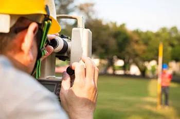
Precise elevation surveying along the shore
The boundary is physically staked on-site to show the legal separation between private and sovereign land.
State-compliant plat preparation
A specialized survey map is created that meets all state requirements for waterfront permitting and development.
Need a Mean High Water Survey for your project?
Ready to provide the precision data your project needs. We respond to all requests within 1 hour.
Order Your SurveyCall Support
Available Mon-Fri

Start Your Project
We respond to all requests within 1 hour during business hours. Secure, transparent estimates without the wait.
MAITLAND FLORIDA 32794