About our Topographic Survey Excellence
Before engineers can design roads or architects can place buildings, they need to know the shape of the land. Topographic surveys locate all natural and man-made features and elevations, providing the critical base map for all site development planning.
The Visionland Process
Research of utility records
We coordinate with utility companies to identify and map the locations of underground pipes, cables, and conduits.
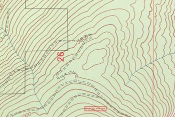
Intensive grid-pattern field measurement
Our crew maps the elevation changes across the site to create accurate 3D contour lines.
Location of trees, roads, and utilities
All significant natural and man-made features are precisely located to provide a complete site picture.
Creation of 3D CAD deliverable
A final high-resolution digital model is produced, serving as the essential foundation for site engineering.
Need a Topographic Survey for your project?
Ready to provide the precision data your project needs. We respond to all requests within 1 hour.
Order Your SurveyCall Support
Available Mon-Fri


Start Your Project
We respond to all requests within 1 hour during business hours. Secure, transparent estimates without the wait.
MAITLAND FLORIDA 32794